![](/images/other/stat-length.png)
![Tour Zu Fuß San Cristóbal de La Laguna - Camino de Candelaria de La Laguna - Photo](https://media.geolcdn.com/t/1900/400/46a6c584-6b34-413d-af5d-29678a736eb8.jpeg&format=pjpeg&maxdim=2)
Camino de Candelaria de La Laguna
SityTrail - itinéraires balisés pédestres
Tous les sentiers balisés d’Europe GUIDE+
![Länge](/images/other/stat-length.png)
Länge
21 km
![Maximale Höhe](https://static1.geolcdn.com/siteimages/upload/files/1508320355ic_sort_altitude_max_24dp.png)
Maximale Höhe
632 m
![Positive Höhendifferenz](https://static1.geolcdn.com/siteimages/upload/files/1508320355ic_sort_den_pos_24dp.png)
Positive Höhendifferenz
344 m
![Km-Effort](/images/other/stat-length.png)
Km-Effort
27 km
![Min. Höhe](https://static1.geolcdn.com/siteimages/upload/files/1508320355ic_sort_altitude_min_24dp.png)
Min. Höhe
5 m
![Negative Höhendifferenz](https://static1.geolcdn.com/siteimages/upload/files/1508320355ic_sort_den_neg_24dp.png)
Negative Höhendifferenz
882 m
![Boucle](https://static1.geolcdn.com/siteimages/upload/files/16400158638029165_repeat_loop_refresh_sync_direction_icon.png)
Boucle
Nein
Kennzeichnung
Erstellungsdatum :
2022-02-14 14:25:17.504
Letzte Änderung :
2022-02-14 14:25:17.504
![Zu Fuß](https://static1.geolcdn.com/sitytour/trail-icons/100.png)
6h09
Schwierigkeit : Medium
![Scannen Sie diesen QR-Code, um die Tour in der SityTrail-Anwendung zu öffnen](https://capi.geolives.com/qq0zvz2zws4bq2lad0pu/sitytour/trails/3108540/qr.png?size=200)
Kostenlosegpshiking-Anwendung
Über SityTrail
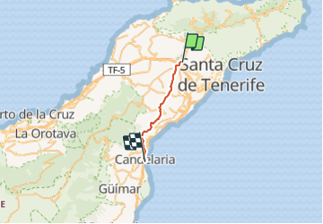
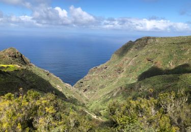
Tour Zu Fuß von 21 km verfügbar auf Kanarische Inseln, Santa Cruz de Tenerife, San Cristóbal de La Laguna. Diese Tour wird von SityTrail - itinéraires balisés pédestres vorgeschlagen.
Beschreibung
The Way is signposted annually
Ort
Land:
Spain
Region :
Kanarische Inseln
Abteilung/Provinz :
Santa Cruz de Tenerife
Kommune :
San Cristóbal de La Laguna
Standort:
Unknown
Gehen Sie:(Dec)
Gehen Sie:(UTM)
371417 ; 3151734 (28R) N.
Kommentare
Touren in der Umgebung
![Tour Zu Fuß Tegueste - El bosque de los enigmas - Photo](https://media.geolcdn.com/t/375/260/1a03fed7-fb28-4a0e-9d0f-13adda6bed3b.jpeg&format=jpg&maxdim=2)
![Zu Fuß Zu Fuß](https://static1.geolcdn.com/sitytour/trail-icons/100.png)
El bosque de los enigmas
Zu Fuß
Einfach
(1)
Tegueste,
Kanarische Inseln,
Santa Cruz de Tenerife,
Spain
![](/images/other/stat-length.png)
4,5 km | 6,7 km-effort
1h 31min
![](https://static1.geolcdn.com/siteimages/upload/files/16400158638029165_repeat_loop_refresh_sync_direction_icon.png)
Ja
![Tour Zu Fuß Tegueste - SL-TG 03 Las Canteras-Las Toscas - Photo](https://media.geolcdn.com/t/375/260/9b02a4e1-6549-4943-9eb8-9ef13f2363ff.jpeg&format=jpg&maxdim=2)
![Zu Fuß Zu Fuß](https://static1.geolcdn.com/sitytour/trail-icons/100.png)
SL-TG 03 Las Canteras-Las Toscas
Zu Fuß
Einfach
Tegueste,
Kanarische Inseln,
Santa Cruz de Tenerife,
Spain
![](/images/other/stat-length.png)
6,4 km | 9,8 km-effort
2h 13min
![](https://static1.geolcdn.com/siteimages/upload/files/16400158638029165_repeat_loop_refresh_sync_direction_icon.png)
Nein
![Tour Zu Fuß San Cristóbal de La Laguna - SL-TG 02 El Portezuelo-El Socorro - Photo](https://media.geolcdn.com/t/375/260/439141b9-9225-42e5-aa29-a8f38c84a55c.jpeg&format=jpg&maxdim=2)
![Zu Fuß Zu Fuß](https://static1.geolcdn.com/sitytour/trail-icons/100.png)
SL-TG 02 El Portezuelo-El Socorro
Zu Fuß
Einfach
San Cristóbal de La Laguna,
Kanarische Inseln,
Santa Cruz de Tenerife,
Spain
![](/images/other/stat-length.png)
5,8 km | 7,8 km-effort
1h 46min
![](https://static1.geolcdn.com/siteimages/upload/files/16400158638029165_repeat_loop_refresh_sync_direction_icon.png)
Nein
![Tour Zu Fuß San Cristóbal de La Laguna - Camino de Candelaria de Tegueste - Photo](https://media.geolcdn.com/t/375/260/be0e3d77-69cd-4aea-addd-378ac79d031e.jpeg&format=jpg&maxdim=2)
![Zu Fuß Zu Fuß](https://static1.geolcdn.com/sitytour/trail-icons/100.png)
Camino de Candelaria de Tegueste
Zu Fuß
Einfach
San Cristóbal de La Laguna,
Kanarische Inseln,
Santa Cruz de Tenerife,
Spain
![](/images/other/stat-length.png)
5 km | 7,5 km-effort
1h 41min
![](https://static1.geolcdn.com/siteimages/upload/files/16400158638029165_repeat_loop_refresh_sync_direction_icon.png)
Nein
![Tour Andere Aktivitäten San Cristóbal de La Laguna - anaga - Photo](https://media.geolcdn.com/t/375/260/ext.jpg?maxdim=2&url=https%3A%2F%2Fservices.sitytrail.com%2FGeolivesWS%2FDownloadMedia.ashx%3FTrailID%3D909895%26Media%3D20180221132357.jpg)
![Andere Aktivitäten Andere Aktivitäten](https://static1.geolcdn.com/sitytour/trail-icons/900.png)
anaga
Andere Aktivitäten
Sehr leicht
San Cristóbal de La Laguna,
Kanarische Inseln,
Santa Cruz de Tenerife,
Spain
![](/images/other/stat-length.png)
6,7 km | 9,6 km-effort
3h 23min
![](https://static1.geolcdn.com/siteimages/upload/files/16400158638029165_repeat_loop_refresh_sync_direction_icon.png)
Nein
![Tour Wandern San Cristóbal de La Laguna - la Laguna tenerif - Photo](https://media.geolcdn.com/t/375/260/ext.jpg?maxdim=2&url=https%3A%2F%2Fstatic1.geolcdn.com%2Fsiteimages%2Fupload%2Ffiles%2F1553511878bg_sport_marche.png)
![Wandern Wandern](https://static1.geolcdn.com/sitytour/trail-icons/101.png)
la Laguna tenerif
Wandern
Einfach
San Cristóbal de La Laguna,
Kanarische Inseln,
Santa Cruz de Tenerife,
Spain
![](/images/other/stat-length.png)
4,2 km | 4,6 km-effort
1h 53min
![](https://static1.geolcdn.com/siteimages/upload/files/16400158638029165_repeat_loop_refresh_sync_direction_icon.png)
Ja
![Tour Wandern Tegueste - Ballade Tegueste - Photo](https://media.geolcdn.com/t/375/260/ext.jpg?maxdim=2&url=https%3A%2F%2Fstatic1.geolcdn.com%2Fsiteimages%2Fupload%2Ffiles%2F1553511878bg_sport_marche.png)
![Wandern Wandern](https://static1.geolcdn.com/sitytour/trail-icons/101.png)
Ballade Tegueste
Wandern
Medium
Tegueste,
Kanarische Inseln,
Santa Cruz de Tenerife,
Spain
![](/images/other/stat-length.png)
10,5 km | 20 km-effort
2h 51min
![](https://static1.geolcdn.com/siteimages/upload/files/16400158638029165_repeat_loop_refresh_sync_direction_icon.png)
Ja
![Tour Wandern San Cristóbal de La Laguna - anaga tenerif - Photo](https://media.geolcdn.com/t/375/260/ext.jpg?maxdim=2&url=https%3A%2F%2Fstatic1.geolcdn.com%2Fsiteimages%2Fupload%2Ffiles%2F1553511878bg_sport_marche.png)
![Wandern Wandern](https://static1.geolcdn.com/sitytour/trail-icons/101.png)
anaga tenerif
Wandern
Sehr leicht
San Cristóbal de La Laguna,
Kanarische Inseln,
Santa Cruz de Tenerife,
Spain
![](/images/other/stat-length.png)
1,4 km | 2,5 km-effort
47min
![](https://static1.geolcdn.com/siteimages/upload/files/16400158638029165_repeat_loop_refresh_sync_direction_icon.png)
Ja
![Tour Andere Aktivitäten San Cristóbal de La Laguna - 12k_jardina_circular - Photo](https://media.geolcdn.com/t/375/260/ext.jpg?maxdim=2&url=https%3A%2F%2Fstatic1.geolcdn.com%2Fsiteimages%2Fupload%2Ffiles%2F1545311037marcheuse_200dpi.jpg)
![Andere Aktivitäten Andere Aktivitäten](https://static1.geolcdn.com/sitytour/trail-icons/900.png)
12k_jardina_circular
Andere Aktivitäten
Sehr leicht
San Cristóbal de La Laguna,
Kanarische Inseln,
Santa Cruz de Tenerife,
Spain
![](/images/other/stat-length.png)
11,6 km | 19,8 km-effort
Unbekannt
![](https://static1.geolcdn.com/siteimages/upload/files/16400158638029165_repeat_loop_refresh_sync_direction_icon.png)
Ja